

SK63Z4_WGS84_KML

SK-63_Z4 WGS84 pairs to KML Coverter
- Active · last change 6-23-2025
- ★ 1 on GitHub
README

SK63Z4-WGS84_KML
SK-63_Z4 WGS84 pairs to KML Coverter·
[Report Bug](https://github.com/scadl/SK63Z4_WGS84_KML/issues/new?labels=bug&template=bug-report---.md)
·
[Request Feature](https://github.com/scadl/SK63Z4_WGS84_KML/issues/new?labels=enhancement&template=feature-request---.md)
·About The Project / О проекте
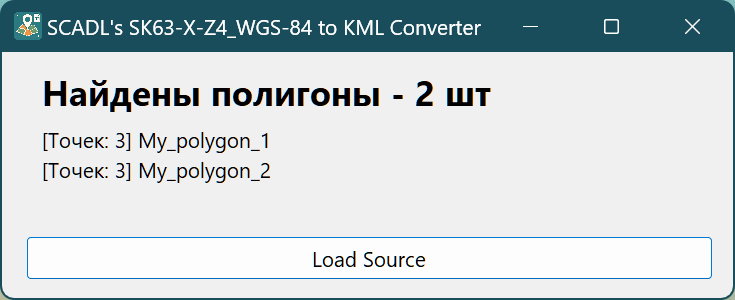
This app - is simple GUI wrapper for my script, able to easy automatic converting of coordinates pairs, representing geo-referenced polygons to structured XML KML. Because the app accepts simple TXT files, filled with the specific pattern, I added special prefix (scadlcoord) to required file extension, for easy filtering. If you give app right formatted txt, it wil ask you a place and a name for saving result kml, then show the result in main window:
- Amount of found polygons - at the title
- Names of all found polygons - at the window body
- Count of points for each polygon - as prefix to their names.
You can stretch the window, if your list doesn't fit. All the styles for polygons will be generated automatically, with random colors for borders (always opaque) and fills (always 30% opacity)
The main regiments to input file:
- Plaint TXT file made in notepad (or other text editor, not Word processor!)
- One empty string (row) between polygon blocks
- Two empty strings (rows) at the end of file
- Each section required to have
- Any polygon title at the first row (do not break to multiple lines)
- Only 2 sections with coord list, in each block
- This sections required to have
СК-1963andWGS84in their titles
Example of input file Objects.scadlcoord.txt
My_polygon_1
>>> Any_prefix СК-1963 Any_suffix
4791749.934,4253966.837
4774996.127,4249029.400
4789202.224,4269260.767
>>> Any_prefix WGS84 Any_suffix
43.341915, 31.930971
43.190803, 31.871638
43.319767, 32.119719

My_polygon_2
>>> Any_prefix СК-1963 Any_suffix
4801115.312,4264757.835
4783792.144,4264905.042
4791842.314,4278875.383
>>> Any_prefix WGS84 Any_suffix
43.426794, 32.063440
43.270881, 32.066370
43.343863, 32.238143
Example output file ObjectsResult.kml
<?xml version="1.0" encoding="utf-8"?>
<kml xmlns="http://www.opengis.net/kml/2.2">
    <Document>
        <Style id="style0">
            <LineStyle>
                <color>FF8C97B7</color>
                <width>3</width>
            </LineStyle>
            <PolyStyle>
                <color>AAD89ADB</color>
            </PolyStyle>
        </Style>
        <Placemark>
            <name>My_polygon_1</name>
            <description>
                >>> СК-1963
                4253966.837,4791749.934,0
                4249029.400,4774996.127,0
                4269260.767,4789202.224,0
                >>> WGS84
                31.930971,43.341915,0
                31.871638,43.190803,0
                32.119719,43.319767,0
            </description>
            <styleUrl>#style0</styleUrl>
            <Polygon>
                <outerBoundaryIs>
                    <LinearRing>
                        <coordinates>
                            31.930971,43.341915,0
                            31.871638,43.190803,0
                            32.119719,43.319767,0
                            31.930971,43.341915,0
                        </coordinates>
                    </LinearRing>
                </outerBoundaryIs>
            </Polygon>
        </Placemark>
        <Style id="style1">
            <LineStyle>
                <color>FF8BD86C</color>
                <width>3</width>
            </LineStyle>
            <PolyStyle>
                <color>AA9FA562</color>
            </PolyStyle>
        </Style>
        <Placemark>
            <name>My_polygon_2</name>
            <description>
                >>> СК-1963
                4264757.835,4801115.312,0
                4264905.042,4783792.144,0
                4278875.383,4791842.314,0
                >>> WGS84
                32.063440,43.426794,0
                32.066370,43.270881,0
                32.238143,43.343863,0
            </description>
            <styleUrl>#style1</styleUrl>
            <Polygon>
                <outerBoundaryIs>
                    <LinearRing>
                        <coordinates>
                            32.063440,43.426794,0
                            32.066370,43.270881,0
                            32.238143,43.343863,0
                            32.063440,43.426794,0
                        </coordinates>
                    </LinearRing>
                </outerBoundaryIs>
            </Polygon>
        </Placemark>
    </Document>
</kml>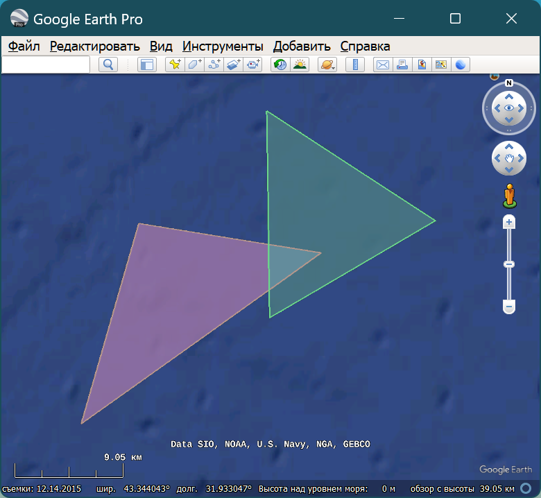
Contact
Alexander K.D. - scad.luncher@gmail.com
Project Link: [https://github.com/scadl/SK63Z4_WGS84_KML](https://github.com/scadl/SK63Z4_WGS84_KML)
This app built With Lazarus