

Catalog · How the catalog works
ray

X-Plane 12 Auto Missile Guidance Plugin
- ★ 2 on GitHub
Anyone may press Interesting, signed in or not. It helps others find this project.
README
X-Plane 12 JTAC Coordinate System Plugin
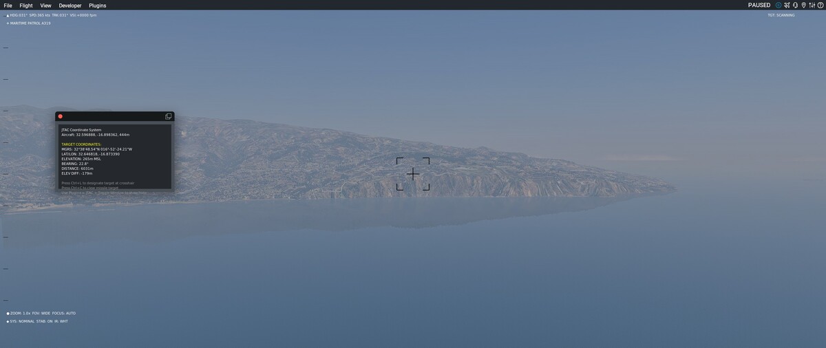
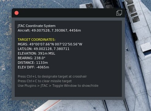
Overview
This plugin implements a realistic Joint Terminal Attack Controller (JTAC) coordinate designation system for X-Plane 12. It combines precise terrain probing with missile guidance capabilities, allowing pilots to designate targets and guide missiles to specific coordinates using real-world military procedures.
Installation
Download the Plugin from the Release and place it in \X-Plane 12\Resources\plugins
** NOTE: This plugin calculates Target Coordinates from the center view of your screen. By Pressing CTRL + L the target is "selected" and you can arm & fire your missiles. ** ** The missiles need to be in "internal radar" mode, can be selected in Planemaker. **
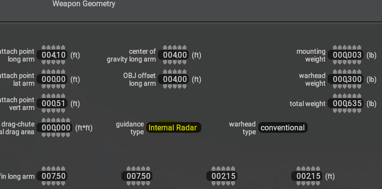
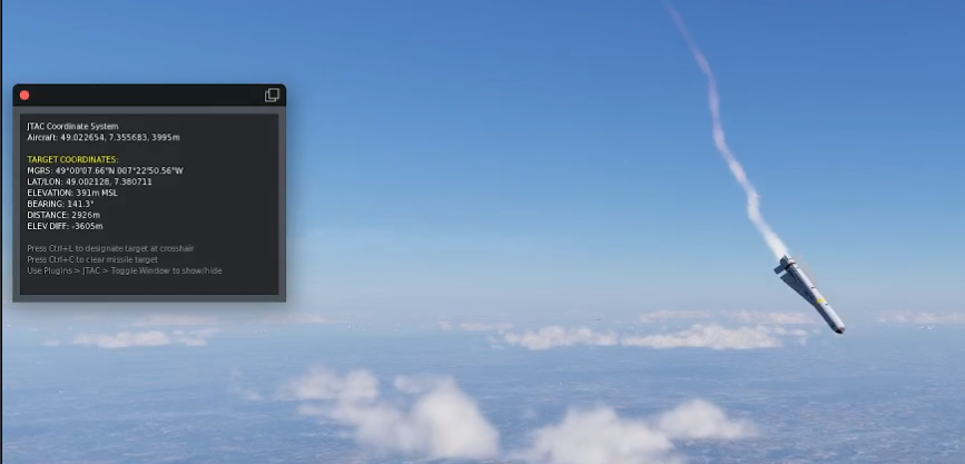
License
This project is licensed under the MIT License - see the LICENSE file for details.
How It Works
1. Terrain Probing & Ray Casting
The plugin uses sophisticated 3D ray casting to determine where the pilot is looking and find the exact terrain intersection point:
// Convert screen coordinates to world ray using X-Plane's view system
bool ScreenToWorldRay(int screenX, int screenY,
                     float* rayStartX, float* rayStartY, float* rayStartZ,
                     float* rayDirX, float* rayDirY, float* rayDirZ)
Why This Works:
- Camera Position Detection: Uses X-Plane's view system datarefs (
sim/graphics/view/view_x,view_y,view_z) to get the actual camera position, not the aircraft position - View Angle Calculation: Incorporates real field of view (
sim/graphics/view/field_of_view_deg) and screen aspect ratio for accurate ray direction - Coordinate Transformation: Converts 2D screen coordinates to 3D world rays using proper OpenGL perspective projection math
2. Binary Search Terrain Intersection
The plugin uses a divide-and-conquer approach to find precise terrain intersection points:
// Binary search for terrain intersection
while ((maxDistance - minDistance) > 1.0f && iterations < maxIterations) {
    currentDistance = (minDistance + maxDistance) * 0.5f;

    // Calculate test point along ray
    float testX = rayStartX + rayDirX * currentDistance;
    float testY = rayStartY + rayDirY * currentDistance;
    float testZ = rayStartZ + rayDirZ * currentDistance;

    // Probe terrain at this point
    XPLMProbeResult result = XPLMProbeTerrainXYZ(gTerrainProbe, testX, testY, testZ, &probeInfo);

    if (result == xplm_ProbeHitTerrain) {
        if (testY < probeInfo.locationY) {
            // We're underground - intersection is closer
            maxDistance = currentDistance;
        } else {
            // We're above ground - intersection is further
            minDistance = currentDistance;
        }
    }
}
Why This Method:
- Accuracy: Achieves 1-meter precision through iterative refinement
- Performance: Only requires ~50 iterations maximum vs. thousands of linear probes
- Reliability: Works with X-Plane's terrain mesh system regardless of terrain complexity
- Range: Supports up to 30km targeting range
3. Coordinate System Integration
The plugin converts between multiple coordinate systems for military compatibility:
// Convert back to world coordinates
XPLMLocalToWorld(probeInfo.locationX, probeInfo.locationY, probeInfo.locationZ,
               &target->latitude, &target->longitude, &target->elevation);
Coordinate Transformations:
- Local Coordinates: X-Plane's internal meter-based coordinate system
- World Coordinates: Latitude/Longitude/Elevation (WGS84)
- MGRS Format: Military Grid Reference System for tactical communication
- Bearing/Distance: Great circle calculations for navigation
4. Missile Guidance System
The plugin implements realistic missile physics with proportional navigation:
void CalculateSmoothGuidance(int missileIndex, float deltaTime) {
    // Calculate vector to target
    float toTargetX = gGuidanceTarget.localX - missileX;
    float toTargetY = gGuidanceTarget.localY - missileY;
    float toTargetZ = gGuidanceTarget.localZ - missileZ;

    // Very gentle steering - small correction factor
    float steeringGain = 0.05f; // Very small - smooth changes only

    // Calculate new direction (interpolate very slowly toward target)
    float newDirX = currentDirX + (desiredDirX - currentDirX) * steeringGain;
    float newDirY = currentDirY + (desiredDirY - currentDirY) * steeringGain;
    float newDirZ = currentDirZ + (desiredDirZ - currentDirZ) * steeringGain;
}
Why This Approach:
- Smooth Flight: Uses gentle steering (0.05 gain) to avoid "vibrating" missiles
- Physics Preservation: Doesn't interfere with X-Plane's flight model
- Realistic Behavior: Implements proportional navigation used in real missile systems
- Stability: Prevents oscillation and erratic behavior
Technical Architecture
Plugin Components
- probe.cpp - Main plugin with terrain probing and JTAC functionality
- missile_guidance.cpp - Missile physics and guidance system
- missile_guidance.h - C interface for missile system integration
Key Features
Real-Time Terrain Analysis
- Uses X-Plane's
XPLMProbeTerrainXYZAPI for accurate terrain data - Binary search algorithm provides meter-level precision
- Works with all X-Plane scenery including custom terrain
Military-Standard Coordinate Display
- MGRS Format:
31UCQ1234567890style grid references - Decimal Degrees: High-precision lat/lon coordinates
- Bearing/Distance: Great circle navigation data
- Elevation: MSL altitude of target point
Weapon System Integration
- Interfaces with X-Plane's weapon datarefs (
sim/weapons/x,sim/weapons/vx, etc.) - Supports multiple missile types through array-based datarefs
- Real-time guidance updates at 20Hz (0.05 second intervals)
Controls
- Ctrl+L: Designate target at screen crosshair
- Ctrl+C: Clear current missile target
Installation
- Compile the plugin using the provided Makefile:
make - Copy the built plugin folder to X-Plane 12:
X-Plane 12/Resources/plugins/JTACCoords/
Technical Requirements
- X-Plane 12: Uses modern X-Plane SDK features
- MinGW-w64: For cross-compilation to Windows
- OpenGL: For graphics and coordinate transformations
- C++11: Modern C++ features for reliability
Why This System Works
1. Precision Through Mathematics
The ray casting system uses proper 3D geometry and OpenGL perspective projection to ensure that where you look is exactly where the coordinates are calculated.
2. Performance Through Algorithms
Binary search reduces computational complexity from O(n) to O(log n), making real-time terrain probing feasible even at long ranges.
3. Realism Through Physics
The missile guidance system uses actual proportional navigation algorithms while respecting X-Plane's flight model, resulting in realistic missile behavior.
4. Compatibility Through Standards
All coordinate outputs follow military standards (MGRS) and aviation standards (WGS84), ensuring compatibility with real-world navigation systems.
Development History
This system evolved from a simple coordinate display to a complete JTAC solution:
- Initial Implementation: Basic terrain probing with aircraft position
- Camera Integration: Fixed to use actual view position instead of aircraft position
- Ray Casting Refinement: Implemented binary search for precision
- Missile Integration: Added weapon system integration
- Physics Optimization: Simplified guidance to prevent oscillation
- Final Polish: Made plugin toggleable and added menu entry for convenience
The key breakthrough was realizing that accurate targeting requires using the camera/view position rather than the aircraft position, combined with proper binary search terrain intersection rather than linear probing.
Contributign & Future Enhancements
Contributing
If you want to help making this plugin more "mature" - you are welcome to do so!
Future Enhancements
- Integration with FLIR camera systems for visual targeting
- Support for moving targets
- Multiple simultaneous target designation
- Advanced missile guidance modes (maybe homing?, etc.)
- Integration with external navigation systems
This plugin demonstrates how precise mathematical modeling combined with X-Plane's robust API can create realistic military simulation capabilities within the flight simulator environment.