

Catalog · How the catalog works
Delphi-GeoMap-Component

Native Delphi map component with GeoJSON support, markers, and interactive navigation.
- ★ 6 on GitHub
Anyone may press Interesting, signed in or not. It helps others find this project.
README
Delphi GeoMap Component
A pure Delphi VCL component for displaying geographic maps with markers, country highlighting, and interactive features.
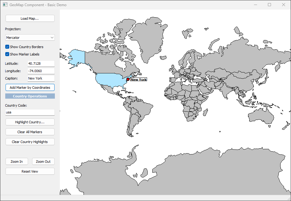
Features
✅ Zero Dependencies - Pure Delphi, no external libraries
✅ GeoJSON Support - Loads standard GeoJSON map data
✅ Map Projections - Mercator and Equirectangular
✅ Markers - Add markers by coordinates or country code
✅ Interactive - Click, hover, zoom, pan
✅ Customizable - Colors, borders, events
✅ Lightweight - Fast native rendering
Quick Start
Installation
Step 1: Compile the Runtime Package
- Open Delphi IDE
- Navigate to:
Packages/GeoMapComponents.dpk - Right-click the project and select Compile
- Wait for "Compile successful" message
- Close this package (you're done with it)
Step 2: Install the Design-Time Package
- Navigate to:
Packages/GeoMapComponentsDesign.dpk - Right-click the project and select Install
- You should see a message: "Package GeoMapComponentsDesign has been installed"
- The component will appear in the Tool Palette under "GeoMap" category
Step 3: Add Source to Library Path
- Tools → Options → Language → Delphi → Library
- Click "..." next to Library Path
- Add:
<YourPath>\Delphi GeoMap Component\Source - Click OK
Basic Usage
procedure TForm1.FormCreate(Sender: TObject);
begin
  // Load world map
  GeoMap1.LoadMapFromFile('world.geojson');

  // Add markers
  GeoMap1.AddMarker(40.7128, -74.0060, 'New York');
  GeoMap1.AddMarker(51.5074, -0.1278, 'London');

  // Highlight countries
  GeoMap1.SetCountryColor('usa', clRed);
  GeoMap1.SetCountryColor('gbr', clBlue);
end;
Component Properties
| Property | Type | Description |
|---|---|---|
ProjectionType |
TMapProjectionType | Map projection (Mercator/Equirectangular) |
ShowCountryBorders |
Boolean | Show country borders |
BorderColor |
TColor | Border line color |
BorderWidth |
Integer | Border line width |
DefaultCountryColor |
TColor | Default fill color for countries |
HoverColor |
TColor | Color when hovering over country |
ZoomLevel |
Single | Current zoom level (0.5-10.0) |
Component Methods
Map Loading
LoadMapFromFile(FileName: string)- Load GeoJSON from fileLoadMapFromJSON(JSON: string)- Load GeoJSON from string
Markers
AddMarker(Lat, Lon: Double; Caption: string): TGeoMarker- Add marker by coordinatesClearMarkers- Remove all markers
Navigation
ZoomIn- Increase zoom levelZoomOut- Decrease zoom levelResetView- Reset to default viewCenterOn(Lat, Lon: Double)- Center map on coordinatesCenterOnCountry(CountryCode: string)- Center on country
Country Operations
SetCountryColor(CountryCode: string; Color: TColor)- Set country fill colorSetCountryValue(CountryCode: string; Value: Double)- Set country data valueFindCountryAt(X, Y: Integer): TGeoCountry- Get country at screen position
Coordinate Conversion
LatLonToScreen(Point: TGeoPoint): TPointF- Convert geo to screen coordinatesScreenToLatLon(Point: TPointF): TGeoPoint- Convert screen to geo coordinates
Events
OnMarkerClick(Sender: TObject; Marker: TGeoMarker)- Fired when marker is clickedOnCountryClick(Sender: TObject; Country: TGeoCountry)- Fired when country is clicked
File Structure
Delphi GeoMap Component/
????????? Packages/
???   ????????? GeoMapComponents.dpk        # Runtime package
???   ????????? GeoMapComponentsDesign.dpk  # Design-time package
????????? Ressources/
???   ????????? world.geojson               # World map data
????????? Samples/
???   ????????? BasicMapDemo/               # Basic usage example
????????? Source/
???   ????????? GeoMap.Types.pas            # Core data types
???   ????????? GeoMap.Projection.pas       # Map projections
???   ????????? GeoMap.Data.pas             # GeoJSON parser
???   ????????? GeoMap.Markers.pas          # Marker system
???   ????????? GeoMap.VCL.pas              # Main VCL component
???   ????????? GeoMap.VCL.Register.pas     # IDE registration
????????? demo.png                        # Screenshot
????????? README.md                       # This file
????????? USAGE_GUIDE.md                  # Detailed usage guide
GeoJSON Format
The component uses standard GeoJSON FeatureCollection format:
{
  "type": "FeatureCollection",
  "features": [
    {
      "type": "Feature",
      "properties": {
        "shortName": "usa",
        "name": "United States"
      },
      "geometry": {
        "type": "MultiPolygon",
        "coordinates": [[[[lon, lat], ...]]]
      }
    }
  ]
}
Contributing
Contributions are welcome! If you have suggestions or bug fixes, please fork the repository and submit a pull request.
Made with ❤️ using Delphi RAD Studio