

Catalog · How the catalog works
MaxMind-GeoIP-Delphi

A lightweight Delphi VCL application demonstrating IP geolocation using MaxMind's GeoIP database.
- ★ 14 on GitHub
Anyone may press Interesting, signed in or not. It helps others find this project.
README
DelphiGeoLocator
A lightweight Delphi VCL application for IP geolocation using MaxMind's GeoIP database to identify countries and display their flags.
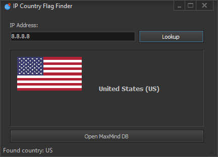
🌎 Features
- IP Lookup: Quickly identify the country associated with any IP address
- Visual Identification: Display country flags for easy recognition
- Multiple Database Support: Compatible with various MaxMind GeoIP database formats
- Simple UI: User-friendly interface with intuitive controls
- Status Updates: Integrated status bar provides real-time feedback
- Flag Display: Automatic loading of country flags in PNG or JPG formats
🔍 Overview
This application demonstrates how to implement IP geolocation in Delphi applications using MaxMind's GeoIP database. Key components include:
- TMMDBReader: Core component for reading MaxMind database files
- IP Parsing: Conversion from string format to usable IP address objects
- Database Selection: Open and select different MaxMind database files
- Country Identification: Extract country codes and names from IP lookup
- Flag Display: Load and display country flags based on ISO country codes
🛠️ Requirements
- Delphi RAD Studio: Developed and tested with recent versions
- VCL Components: Uses standard Visual Component Library
- MaxMind GeoIP Database: Requires a MaxMind database file (.mmdb)
- Country Flags: Requires flag images in PNG or JPG format (not included)
- Required Libraries: The "Required Libraries (add to your IDE libray paths)" folder contains components necessary for compilation - add these to your IDE library paths before building
📋 Usage Instructions
- Add the contents of the "Required Libraries (add to your IDE libray paths)" folder to your Delphi IDE library paths
- Launch the application
- Click "Open DB" to select a MaxMind GeoIP database file
- Enter an IP address in the provided field
- Click "Lookup" to retrieve country information
- View country name, code, and flag (if available)
💾 Database Resources
MaxMind offers various GeoIP databases:
- Free GeoLite2 databases available with registration
- Commercial GeoIP2 databases for higher accuracy Visit MaxMind's website for more information.
🏁 Flag Resources
Country flags should be placed in a "Flags" directory in the same location as the executable.
- Flags should be named using the two-letter ISO country code (e.g., US.png)
- Supported formats: PNG and JPG (PNG recommended)
⚙️ Implementation Details
- Database Handling: Supports both Country and City type databases
- Flag Loading: Automatically tries different formats and provides status feedback
- Error Handling: Comprehensive error reporting for database and flag loading issues
📜 License
This project is provided as is for educational and research purposes. Use at your own risk.
📧 Contact
Discord: bitmasterxor
Made with ❤️ by BitmasterXor, using Delphi RAD Studio