

Pascal and GIS: what changed
Revision 1 to 2. Removed lines have a minus sign; added lines have a plus sign.
| Old | New | Line | |
|---|---|---|---|
| 1 | 1 | ## Pascal for GIS toolkit | |
| 2 | 2 | ||
| 3 | 3 | <https://macpgmr.github.io/MacXPlatform/PascalDynLibs_3.html> | |
| 4 | 4 | ||
| 5 | 5 | (Note that this article is part of a larger series on how to use compiled Pascal dynamic libraries with a variety of different programming languages.) | |
| 6 | 6 | ||
| 7 | 7 | The Pascal for GIS toolkit includes the source for example apps that demonstrate various ways to use Pascal (and in some cases Lazarus) in developing GIS apps: | |
| 8 | 8 | ||
| 9 | 9 | - Add non-visual geoprocessing functionality to any Pascal app (testgdal, testshapes). | |
| 10 | 10 | ||
| 11 | 11 | - Develop a GIS app using the new GIS map and legend controls for Lazarus LCL (PasCast). | |
| 12 | 12 | ||
| 13 | 13 | - Place non-GIS Pascal code in a separate compiled library, then call the library from various GIS apps: | |
| 14 | 14 | - Simple mapping with a mobile Web app (QxCast) that uses a Pascal FCGI server app. | |
| 15 | 15 | - Simple mapping with a standalone app (SwiftCast). | |
| 16 | 16 | - Clickable read-only map with a Web app (AspCast). | |
| 17 | 17 | - Clickable read-write map with a GIS plugin (PyCast). | |
| 18 | 18 | ||
| 19 | 19 | All of the *Cast example apps use the same Pascal dynamic library that retrieves weather forecast data via the National Digital Forecast Database (NDFD) Web service. | |
| 20 | 20 | ||
| 21 | 21 | ## OpenGPSX | |
| 22 | 22 | ||
| 23 | 23 | <https://sourceforge.net/projects/opengpsx/> | |
| 24 | 24 | ||
| 25 | 25 | OpenGPSX Lazarus Component for GPS Interface programming. Decode NMEA messages, Display GPS skyplot view, Display GPS signal strength, Display target navigation. | |
| 26 | 26 | ||
| 27 | 27 | ### Features | |
| 28 | 28 | ||
| 29 | 29 | This is a Lazarus component to demonstrate the real-time tracking and monitoring NMEA-183 compliant from GPS receiver and decode NMEA sentences likes \$GPGGA, \$GPGSA, \$GPGSV, \$GPRMC, \$GPGLL, \$GPVTG, \$GPBOD, \$GPWPL, \$GPRTE | |
| 30 | 30 | ||
| 31 | 31 | - Display GPS skyplot. | |
| 32 | 32 | - Display GPS signal strength. | |
| 33 | 33 | - Display target navigation. | |
| 34 | 34 | - Interfaced to GPS with Serial Port. | |
| 35 | 35 | - Cross-platform, Now works on Windows and Linux. | |
| 36 | 36 | ||
| 37 | - | ||
| 38 | - | ||
| 39 | - | ||
| 40 | - | ||
| 37 | + | 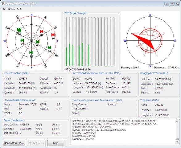 | |
| 41 | 38 | ||
| 42 | 39 | --- | |
| 43 | 40 | *From the Free Pascal wiki, page "Pascal and GIS", as it stood on 2019-02-22 after a change by Serbod, out of the wiki's dump of 2024-05-26. Copyright stays with the author who wrote it, according to the old wiki's [[Licensing]] page. If you have concerns about this material, [message the admin](/wiki-contact).* | |
| 44 | 41 | Category: Libraries |