

Pascal and GIS
Pascal for GIS toolkit
https://macpgmr.github.io/MacXPlatform/PascalDynLibs_3.html
(Note that this article is part of a larger series on how to use compiled Pascal dynamic libraries with a variety of different programming languages.)
The Pascal for GIS toolkit includes the source for example apps that demonstrate various ways to use Pascal (and in some cases Lazarus) in developing GIS apps:
- Add non-visual geoprocessing functionality to any Pascal app (testgdal, testshapes).
- Develop a GIS app using the new GIS map and legend controls for Lazarus LCL (PasCast).
- Place non-GIS Pascal code in a separate compiled library, then call the library from various GIS apps:
- Simple mapping with a mobile Web app (QxCast) that uses a Pascal FCGI server app.
- Simple mapping with a standalone app (SwiftCast).
- Clickable read-only map with a Web app (AspCast).
- Clickable read-write map with a GIS plugin (PyCast).
All of the *Cast example apps use the same Pascal dynamic library that retrieves weather forecast data via the National Digital Forecast Database (NDFD) Web service.
OpenGPSX
https://sourceforge.net/projects/opengpsx/
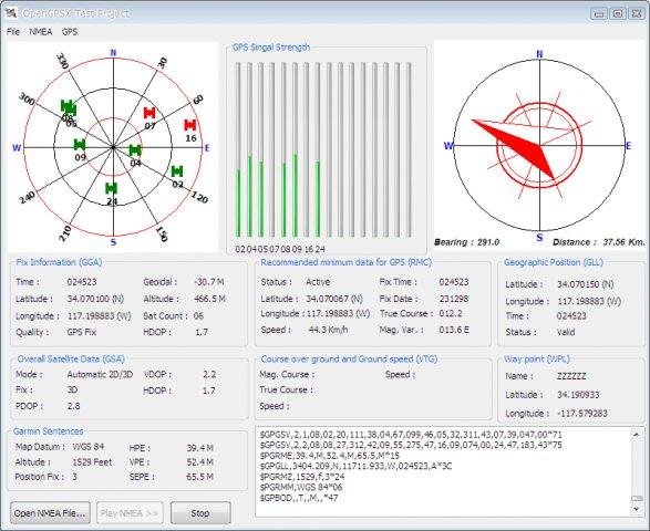
OpenGPSX Lazarus Component for GPS Interface programming. Decode NMEA messages, Display GPS skyplot view, Display GPS signal strength, Display target navigation.
Features
This is a Lazarus component to demonstrate the real-time tracking and monitoring NMEA-183 compliant from GPS receiver and decode NMEA sentences likes $GPGGA, $GPGSA, $GPGSV, $GPRMC, $GPGLL, $GPVTG, $GPBOD, $GPWPL, $GPRTE
- Display GPS skyplot.
- Display GPS signal strength.
- Display target navigation.
- Interfaced to GPS with Serial Port.
- Cross-platform, Now works on Windows and Linux.
From the Free Pascal wiki, page "Pascal and GIS", as it stood on 2019-02-22 after a change by Serbod, out of the wiki's dump of 2024-05-26. Copyright stays with the author who wrote it, according to the old wiki's Licensing page. If you have concerns about this material, message the admin.
Edited on wiki.freepascal.org by 3 people, 2015–2019
From the official wiki's backup of 26 May 2024: who edited this page there, and when. Edits made there after that date were not recorded, and the earlier versions are not shown here; the main page says why.
| When | Who | What changed |
|---|---|---|
| Phil | Created page | |
| FTurtle | added category | |
| Phil | Fixed broken link. | |
| Serbod | added OpenGPSX link and short description |
Talk about this page
Nobody has opened a bench for this page yet. Sign in to open one.